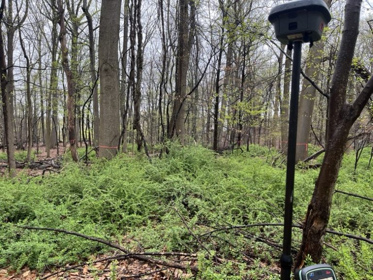
• Home
  • About
  • Equipment
  • Services
  • 3D LASER SCANNING SERVICES
  • GIS
  • FEMA Flood Elevation Certificates
  • Request A Quote
  • FAQ
  • News
  • Employment Opportunities
  • File Upload
  • Laws & Legislation
  • Contact Us

TC Merritts Land Surveyors

Land Surveyors - Westchester County

Follow @TCMerritts_LS

facebook

(914) 769-8003 New York
(203) 622-8899 Connecticut

TC Merritts Offering New, Cutting-Edge Technology!

January 24, 2018

TC Merritts Land Surveyors has acquired the Leica MS60 and now offers 3D laser scanning.

The MS60 is a cutting edge instrument that collects survey data points at a rate of 50,000 points per second. It has an effective range of 400’ to 500’. With several “scan” setups inside a room or of a building, a complete 3D model can be made of the existing conditions. These models are then used to create 2D civil or architectural drawings, 3D computer models, and final survey documents.

Laser scanning has revolutionized the field of land surveying and is fast becoming the preferred method of surveying for all kinds of architectural and construction projects. Laser scanning offers extreme accuracy, which results in precise reproductions of surveyed structures through 3D modeling and similar types of visual presentations.

3D laser scanning provides a better way to quickly and accurately capture as-built conditions for building documentation.  Almost any project that requires accurate as-built information can benefit from 3D imaging.

Laser scanning technology enables us to help our clients plan and execute the most efficient projects by providing detailed spatial information to architects, design professionals, engineers, and builders, thereby allowing them to analyze all components of any facility or site.  These capabilities help us make better decisions during every step of the project – from the planning stages through completion.

Advantages

  • Measurement accuracy of ±2mm (depending on distance to measured object).
  • Unobtrusive data capture methods.
  • Rapid data capture of large volumes with increased accuracy.
  • Measurements can be made quickly and easily when required without the need for return site visits.
  • Shorter project times with a rapid turnaround of information.
  • Point clouds can be checked and measured using free viewing software, from any scan location.
  • highly accurate drawings and models are some of the key benefits of the technology.
  • Digital records – Post-processed point clouds can be directly exported to Autocad, Revit, NavisWorks, Microstation, Rhino, and other CAD platforms.

New Year – New Technology!

January 4, 2017

The technology of surveying is constantly changing. You want to hire a Land Surveying company that can change with it.

Land Surveying technologies are growing in power and use, and so are the software systems and support applications. Because the field has become so highly technological, it is important to look for surveyors with proficiency in relevant software and devices.

TC Merritts Land Surveying is proud to announce their acquisition of one of the latest and greatest surveying tools – The LEICA GS 16.

Working with the leading RTK technology, and combining state-of-art technology and data management, the GS16 meets the highest standards in measurement excellence with RTKplus and SmartLink.

Leica Geosystems is a leading manufacturer of highly accurate land surveying equipment, surveying instruments, and measuring tools for professionals. Leica makes top of the line land surveying products, location systems that capture, visualize and process spatial data through the employment of advanced technologies. ​

When it comes to your land surveying needs, you want the best that the industry can provide. TC Merritts Land Surveyors combines the use of top of the line equipment with a highly qualified staff of professionals, making them one of the most technologically advanced land surveying firm in the County.


Is Going With the Lower Bid Worth the Risk?

December 20, 2016

The biggest mistake you can make as a homeowner is not getting your land surveyed because of the cost of doing so. The second biggest mistake is hiring a land surveyor who is “cheap” or “cheaper” than other land surveyors.

When land surveyors make mistakes, even seemingly minor miscalculations can result in serious and expensive problems for all parties involved. A ten foot discrepancy in placement of a boundary line can cost tens of thousands of dollars to fix.

Cheaper survey bids often mean that the surveyor does not have the most up to date equipment and/or qualified staff. The land surveyor who “does it all” (bids, field work, office computations, drafting) is often the one who opens themselves up to the biggest mistakes.

The Professional Land Surveyor constantly updates field equipment and office computers in order to provide you with the best service. They use high quality land surveying equipment and tools and possess a competent, qualified staff with quality control that the less expensive surveyor is unable to guarantee.

If you needed heart surgery, would you select the cheapest… or the best surgeon? The same principle applies when selecting a Professional Land Surveyor. Remember, many times, the “cheapest” survey costs the most in additional surveying and legal fees. You can spend a few hundred dollars more now, or spend several thousand later.

Chances are a low bid means the surveyor must cut corners and sacrifice quality. Incorrect surveys can cost you way more money than you would have saved by selecting a surveyor based on price alone. As a consumer you should shop for the best value, not the cheapest price.


2016 Fishing Trip

October 15, 2016

img_2064


Understanding Your Survey

October 12, 2016

Have you ever tried to read an old survey or map without success? Terms like ‘rod’ or ‘township’ were once commonplace, and indeed are still in use in specific applications, but most people have no idea what they mean. How can you visualize a property without having a basic understanding of these distances and measurements?

Today’s surveyors continue to use measurement systems that were developed by long-ago surveyors. A rod (sometimes known as a pole) is a measurement of 16.5 feet. Each rod is comprised of 25 links. A two-pole chain is twice the length of a rod, or 16.5 feet. Likewise, a four-pole chain, which is also known as a surveyor’s chain, measures 66 feet (or 100 links). Originally, these measurements were based on the equipment used by surveyors. The chain consisted of 100 links, each measuring 0.66 feet, for the total length of 66 feet. If a distance on a plat map is represented in chains (usually abbreviated Ch), multiply by 66 to determine the number of feet.

The surveyor’s chain was was devised in the seventeenth century by an astronomer so that ten square chains are equivalent to one acre. The pole, or rod, was a wooden pole used for survey measurements. Abbreviated P, it was also known as a ‘perch.’ The more modern term for this piece of equipment and its associated measurement is a ‘rod,’ although the actual wooden rod has not been used by surveyors for over 200 years. Still, the particular length of the rod, or 16.5 feet, had an enormous influence on surveying and land development. According to folklore, the distance of the rod was established in the sixteenth century as the combined length of the left feet of the first 16 men out of church one Sunday. And yet, references to a pole or perch measuring 16.5 feet can be found as early as the thirteenth century.

Survey measurements are also commonly stated in miles or feet. This measurement system is more easily understood by people today, but even this system can be converted into chains and rods. For example, a quarter mile measures 20 chains or 80 rods. One mile, or 5280 feet, can also be stated as 80 chains or 320 rods.

Especially when reading plat maps, you may run into the section and township system of measurement, which is related to the property’s measurement in acres. In this system, one township contains 36 sections. Its total area is 36 square miles. Each section within the township is one square mile, or 640 acres. The sections can be further divided into 1/2 section or 1/4 section.

Today, land measurements are generally in acres. Each acre is equal to 43,560 square feet, or 10 square chains, or 160 square rods. Still, many people cannot visualize the size of an acre. A parcel of land exactly one acre in size and perfectly square measures 208.71 feet along each side. A rectangular acre with a width of 100 feet would measure 435.60 feet long. Each square mile has exactly 640 acres, which is also a section under the township system. Although older surveying measurement systems use seemingly odd distances, most can be easily converted into acres.

Click here for more information on how to read a survey


  • 1
  • 2
  • Next Page »

Menu

  • Home
  • About
  • Equipment
  • Services
  • 3D LASER SCANNING SERVICES
  • GIS
  • FEMA Flood Elevation Certificates
  • Request A Quote
  • FAQ
  • News
  • Employment Opportunities
  • File Upload
  • Laws & Legislation
  • Contact Us

Contact

TC MERRITTS
LAND SURVEYORS
394 Bedford Rd.
Pleasantville NY, 10570
914-769-8003
survey@tcmerritts.com
Fax: 914-769-1419

See What Others Are Saying!

  • 1b2
  • 2b
  • 3b
  • 4b
  • 5b
  • 6b
  • 7b
  • 8b
  • 9b
  • 10b
  • 11b
  • 12b
  • 13bb
  • 14b
  • 15b
  • 16b

Copyright © 2023 TCMerritts